
Srinagar, Sep 1: Jammu and Kashmir is stepping up its disaster preparedness with plans to install advanced early flood warning systems at three major hydropower projects, alongside a GIS-based multi-hazard risk atlas and stronger disaster-risk reduction measures.
The Jammu Kashmir Power Development Corporation (JKPDC) has floated tenders for early warning systems at the 900-MW Baglihar Hydroelectric Project on the Chenab in Ramban, the 105-MW Upper Sindh Hydroelectric Project on the Sindh in Ganderbal and the 37.5-MW Parnai Hydroelectric Project on the Suran near Bafliaz in Poonch.
JKPDC Managing Director official said the initiative is aimed at providing authorities with critical lead time to respond to flash floods and other disasters.
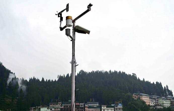
The proposed systems will deploy sensors and communication equipment at strategically identified locations upstream of dams and barrages. The network is expected to provide one to two hours of advance warning, enabling authorities to alert vulnerable communities, initiate evacuations and undertake emergency measures before disaster strikes.
The systems will also incorporate sensor redundancy, allowing backup sensors to automatically take over in case of failure. The condition of instruments, batteries and communication equipment will be monitored in real time to ensure uninterrupted transmission of critical data.
The initiative assumes greater significance as the three hydropower projects are located in mountainous and ecologically fragile areas vulnerable to cloudbursts, flash floods, avalanches and glacial lake outburst floods (GLOFs).
The move comes against the backdrop of increasingly frequent extreme-weather events across J&K, particularly in the Chenab Valley, underlining the need to move beyond a largely post-disaster response towards early warning, prevention and risk reduction.
Following last year’s flash floods in Chishoti in Kishtwar’s Paddar area, expert teams from the Department of Disaster Management, Relief, Rehabilitation and Reconstruction (DMRRR) carried out assessments of vulnerable locations, including landslide-prone zones and areas exposed to potential GLOF threats.
Kishtwar, Doda and Ramban have been identified among the districts facing high landslide vulnerability. High-altitude glacial lakes have emerged as another major concern, with Mundiskar Lake in Kishtwar categorised as highly vulnerable to a potential GLOF.
Kishtwar Deputy Commissioner Pankaj Sharma said the district administration has submitted a ₹35-crore proposal to the DMRRR for disaster mitigation measures. The proposal will be examined by the department’s expert committee.
Officials have also identified five glacial lakes in the Kashmir Himalayas—Bramsar, Chrisar, Nundgol, Bhagsar and Gangabal—as falling under the “very high susceptibility” category for potential GLOFs.
A scientific assessment of 155 glacial lakes based on hydro-geomorphic indicators found that a possible outburst from vulnerable lakes could threaten 2,704 buildings, around 15 major bridges, road infrastructure and a hydropower plant in downstream areas.
The administration is simultaneously pursuing a broader disaster-resilience strategy through a proposed GIS-based multi-hazard risk atlas. The system will use digital terrain and elevation modelling to identify vulnerable zones and strengthen disaster planning.
Authorities also plan to strengthen enforcement of building safety codes, update district disaster management plans and integrate disaster-risk reduction into urban and regional master plans. A dedicated disaster management training institute has also been proposed to enhance the preparedness of officials and other stakeholders.
The government is further planning an MoU with the Geological Survey of India for improved landslide forecasting, while targeted interventions will focus on GLOF monitoring and stabilisation of landslide-prone areas.
For a mountainous and climate-sensitive region such as J&K, the emerging strategy represents an important shift—from responding after disaster to preparing before it. Yet technology alone will not be enough. The real test will be whether warnings are reliable, communication systems remain functional and alerts reach vulnerable communities quickly enough to trigger timely action.
Srinagar, Sep 1: Jammu and Kashmir is stepping up its disaster preparedness with plans to install advanced early flood warning systems at three major hydropower projects, alongside a GIS-based multi-hazard risk atlas and stronger disaster-risk reduction measures.
The Jammu Kashmir Power Development Corporation (JKPDC) has floated tenders for early warning systems at the 900-MW Baglihar Hydroelectric Project on the Chenab in Ramban, the 105-MW Upper Sindh Hydroelectric Project on the Sindh in Ganderbal and the 37.5-MW Parnai Hydroelectric Project on the Suran near Bafliaz in Poonch.
JKPDC Managing Director official said the initiative is aimed at providing authorities with critical lead time to respond to flash floods and other disasters.
The proposed systems will deploy sensors and communication equipment at strategically identified locations upstream of dams and barrages. The network is expected to provide one to two hours of advance warning, enabling authorities to alert vulnerable communities, initiate evacuations and undertake emergency measures before disaster strikes.
The systems will also incorporate sensor redundancy, allowing backup sensors to automatically take over in case of failure. The condition of instruments, batteries and communication equipment will be monitored in real time to ensure uninterrupted transmission of critical data.
The initiative assumes greater significance as the three hydropower projects are located in mountainous and ecologically fragile areas vulnerable to cloudbursts, flash floods, avalanches and glacial lake outburst floods (GLOFs).
The move comes against the backdrop of increasingly frequent extreme-weather events across J&K, particularly in the Chenab Valley, underlining the need to move beyond a largely post-disaster response towards early warning, prevention and risk reduction.
Following last year’s flash floods in Chishoti in Kishtwar’s Paddar area, expert teams from the Department of Disaster Management, Relief, Rehabilitation and Reconstruction (DMRRR) carried out assessments of vulnerable locations, including landslide-prone zones and areas exposed to potential GLOF threats.
Kishtwar, Doda and Ramban have been identified among the districts facing high landslide vulnerability. High-altitude glacial lakes have emerged as another major concern, with Mundiskar Lake in Kishtwar categorised as highly vulnerable to a potential GLOF.
Kishtwar Deputy Commissioner Pankaj Sharma said the district administration has submitted a ₹35-crore proposal to the DMRRR for disaster mitigation measures. The proposal will be examined by the department’s expert committee.
Officials have also identified five glacial lakes in the Kashmir Himalayas—Bramsar, Chrisar, Nundgol, Bhagsar and Gangabal—as falling under the “very high susceptibility” category for potential GLOFs.
A scientific assessment of 155 glacial lakes based on hydro-geomorphic indicators found that a possible outburst from vulnerable lakes could threaten 2,704 buildings, around 15 major bridges, road infrastructure and a hydropower plant in downstream areas.
The administration is simultaneously pursuing a broader disaster-resilience strategy through a proposed GIS-based multi-hazard risk atlas. The system will use digital terrain and elevation modelling to identify vulnerable zones and strengthen disaster planning.
Authorities also plan to strengthen enforcement of building safety codes, update district disaster management plans and integrate disaster-risk reduction into urban and regional master plans. A dedicated disaster management training institute has also been proposed to enhance the preparedness of officials and other stakeholders.
The government is further planning an MoU with the Geological Survey of India for improved landslide forecasting, while targeted interventions will focus on GLOF monitoring and stabilisation of landslide-prone areas.
For a mountainous and climate-sensitive region such as J&K, the emerging strategy represents an important shift—from responding after disaster to preparing before it. Yet technology alone will not be enough. The real test will be whether warnings are reliable, communication systems remain functional and alerts reach vulnerable communities quickly enough to trigger timely action.

© Copyright 2023 brighterkashmir.com All Rights Reserved. Quantum Technologies