BREAKING NEWS
Southwest monsoon covers entire J&K: Me
Srinagar, July 1: The Southwest Monsoon has advanced into most parts of Jammu and Kashmir and Ladakh, covering the entire meteorological subdivision on Wednesday, a day later than the normal onset date of June 30, the Meteorological department Kashmir said on Wednesday.
According to MeT, widespread rainfall was recorded across parts of the Jammu division during the past 24 hours.
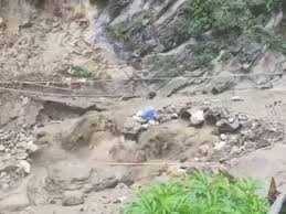
The southwest monsoon made an active onset over J&K and triggered flash floods, cloudbursts and a rise in water levels in some areas of the UT.
One of the major incidents was reported from Guridraman village in the Larnoo area of Anantnag district, where a flash flood struck after heavy afternoon rain.
The sudden rush of water caused panic as several students were inside a local school.
Villagers safely evacuated the children before police, State Disaster Response Force (SDRF) and civil administration teams reached the area to monitor the situation and assess any damage.
Another cloudburst was reported in the remote Tulail Valley of Gurez in north Kashmir's Bandipora district.
Officials said the cloudburst occurred over the Zadigay Nallah near Zadigay village, sending a torrent of water downstream that damaged the Kilshay-Zadigay road and disrupted connectivity. The water level in the Kishanganga Nallah also rose sharply, prompting authorities to keep a close watch on the situation.
In the Chenab Valley, two cloudbursts hit Kalalgisar village in Doda district's Bhalessa region following heavy rainfall. Officials said the situation was being monitored and no loss of life had been reported.
Continuous rain also caused rivers and seasonal streams to swell in Rajouri district. The district administration advised residents living near rivers, nallahs and low-lying areas to remain vigilant and move to safer places if water levels increased further.
Several parts of south Kashmir, including Pahalgam, Ashmuqam and adjoining areas, received widespread rainfall during the day, ending the prolonged heatwave and bringing a noticeable drop in temperatures.
The MeT has forecast generally cloudy weather with one or two spells of light to moderate rain or thundershowers at many places across Jammu and Kashmir from July 1 to 4.
“Heavy rainfall, brief intense showers, thunderstorms, and gusty winds are likely at a few places during this period,” it said.
From July 5 to 8, the weather is expected to remain generally hot and humid, with light to moderate rain or thundershowers at scattered to many places. Brief intense heavy showers are also likely at isolated places in Jammu division.
The MeT has issued an advisory warning that heavy rainfall or brief intense showers at a few locations could trigger localized flash floods, landslides and mudslides in vulnerable areas of Jammu division, the Pir Panjal Range, the Chenab Valley, and adjoining pockets of South Kashmir.
Meanwhile, independent weather observer Faizan Arif said apart from monsoon conditions, three more weak Western Disturbances are set to affect the union Territory this week in quick succession.
The first Western Disturbance is currently influencing the region and will weaken by tomorrow. The second Western Disturbance will arrive tomorrow night and remain effective until Saturday morning. This will be followed by the third Western Disturbance, which is expected to impact the region from Saturday afternoon through Sunday.
"The weak Western Disturbances and the monsoon flow are expected to work in tandem, increasing the likelihood of moderate to heavy showers at times. Their combined influence will also enhance the risk of short-duration intense rainfall, including isolated cloudbursts," Faizan said.
Southwest monsoon covers entire J&K: Me
Srinagar, July 1: The Southwest Monsoon has advanced into most parts of Jammu and Kashmir and Ladakh, covering the entire meteorological subdivision on Wednesday, a day later than the normal onset date of June 30, the Meteorological department Kashmir said on Wednesday.
According to MeT, widespread rainfall was recorded across parts of the Jammu division during the past 24 hours.
The southwest monsoon made an active onset over J&K and triggered flash floods, cloudbursts and a rise in water levels in some areas of the UT.
One of the major incidents was reported from Guridraman village in the Larnoo area of Anantnag district, where a flash flood struck after heavy afternoon rain.
The sudden rush of water caused panic as several students were inside a local school.
Villagers safely evacuated the children before police, State Disaster Response Force (SDRF) and civil administration teams reached the area to monitor the situation and assess any damage.
Another cloudburst was reported in the remote Tulail Valley of Gurez in north Kashmir's Bandipora district.
Officials said the cloudburst occurred over the Zadigay Nallah near Zadigay village, sending a torrent of water downstream that damaged the Kilshay-Zadigay road and disrupted connectivity. The water level in the Kishanganga Nallah also rose sharply, prompting authorities to keep a close watch on the situation.
In the Chenab Valley, two cloudbursts hit Kalalgisar village in Doda district's Bhalessa region following heavy rainfall. Officials said the situation was being monitored and no loss of life had been reported.
Continuous rain also caused rivers and seasonal streams to swell in Rajouri district. The district administration advised residents living near rivers, nallahs and low-lying areas to remain vigilant and move to safer places if water levels increased further.
Several parts of south Kashmir, including Pahalgam, Ashmuqam and adjoining areas, received widespread rainfall during the day, ending the prolonged heatwave and bringing a noticeable drop in temperatures.
The MeT has forecast generally cloudy weather with one or two spells of light to moderate rain or thundershowers at many places across Jammu and Kashmir from July 1 to 4.
“Heavy rainfall, brief intense showers, thunderstorms, and gusty winds are likely at a few places during this period,” it said.
From July 5 to 8, the weather is expected to remain generally hot and humid, with light to moderate rain or thundershowers at scattered to many places. Brief intense heavy showers are also likely at isolated places in Jammu division.
The MeT has issued an advisory warning that heavy rainfall or brief intense showers at a few locations could trigger localized flash floods, landslides and mudslides in vulnerable areas of Jammu division, the Pir Panjal Range, the Chenab Valley, and adjoining pockets of South Kashmir.
Meanwhile, independent weather observer Faizan Arif said apart from monsoon conditions, three more weak Western Disturbances are set to affect the union Territory this week in quick succession.
The first Western Disturbance is currently influencing the region and will weaken by tomorrow. The second Western Disturbance will arrive tomorrow night and remain effective until Saturday morning. This will be followed by the third Western Disturbance, which is expected to impact the region from Saturday afternoon through Sunday.
"The weak Western Disturbances and the monsoon flow are expected to work in tandem, increasing the likelihood of moderate to heavy showers at times. Their combined influence will also enhance the risk of short-duration intense rainfall, including isolated cloudbursts," Faizan said.

© Copyright 2023 brighterkashmir.com All Rights Reserved. Quantum Technologies